
Reports
Reports
-
Indonesian deep demersal fisheries for snappers (Lutjanidae) and groupers (Epinephelidae) are highly productive and of great national as well as international importance in terms of total volume, economic output and food security (Blaber et al., 2005; Cawthorn and Mariani, 2017; Dimarchopoulou et al., 2021; Wibisono et al., 2022). Snapper production in Indonesia was estimated to have contributed some 119,000 Metric Tons (MT) or 45% of the average global supply of just over 264,000 MT annually in the period 2006 to 2013 (Cawthorn and Mariani, 2017). Therewith Indonesia was by far the single largest Lutjanid-producing country in the World during that time. In a separate study on supply lines and official statistics, total snapper landings in Indonesia were estimated to reach close to 117,000 MT in 2007 (Anggraeni, 2012). Groupers make up a smaller part of total landings in the deep demersal fisheries in Indonesia, but are also of considerable economic importance due to the high price per kg for these species (Khasanah et al., 2019). Additional species in these multi-species fisheries include trevallies (Carangidae), emperors (Lethrinidae), grunts (Haemulidae), croakers (Sciaenidae) as well as species from many other co-occurring families (Dimarchopoulou et al., 2021). Snappers and groupers however are the main target species in these fisheries, which operate mostly at depths ranging between 30 and 350 meters. To differentiate from shallow water and coral reef fisheries that target the same families (but a different though somewhat overlapping spectrum of species) we will refer here to the “deep demersal fisheries for snappers and groupers” and we will focus in our assessment of these fisheries on the major target families and species. Issues of species overlap with other fisheries in Indonesia will be briefly discussed in the final chapter of this paper.
-
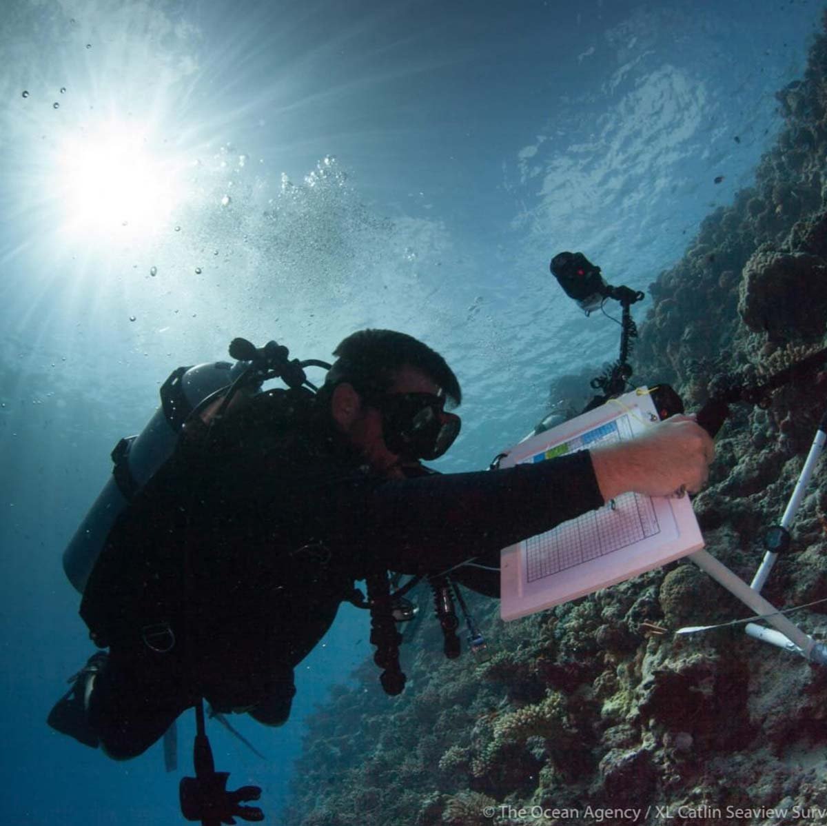
This guide lists the 100 most common species in the deep-slope dropline and demersal longline catches in central and eastern Indonesia. This fishery operates in waters of 50-500 m depth, on the deeper parts of continental shelves and on deep slopes around canyons, sea mounts and continental shelf edges. The dropline and demersal longline fisheries are usually referred to as “snapper” fisheries, even though these fisheries target groupers (Epinephelidae) and emperors (Lethrinidae) as well as snappers (Lutjanidae). Several other families of valuable species are also common in the catch.
-
This manual for identification guide for deepwater fisheries targeting snappers, groupers, and emperors in Indonesia is the result of a partnership between The Nature Conservancy, the Indonesia Ministry of Marine Affairs and Fisheries, and a total of 2651 captains of fishing vessels operating in Indonesia’s archipelagic waters. Focusing on the 100 most common species caught in this fishery, it complements comprehensive taxonomic identification keys such as the FAO’s The Living Marine Resources Of The Western Central Pacific2, and guides for neighboring seas such as Rome and Newman’s North Coast Fish Identification Guide3.
-
This guide to length based stock assessment of the Indonesian deep demersal fisheries was prepared for Yayasan Konservasi Alam Nusantara (YKAN), in support of TNC’s “SNAPPER” Fisheries Conservation Project. In the early stages of this program it was recognized that all stakeholders involved in these fisheries (including fishers, buyers, processors, traders, retailers, consumers, managers, NGO workers, government agencies, scientific and educational institutions, etc.) would benefit from the development of (1) a dedicated fish species identification guide for the Indonesian snapper fisheries, and (2) a guide that explains available tools for length-based assessment of the status and trends in these fisheries.
-
Deep demersal fisheries in Indonesia yielded close to 120,000 Metric Tons of fish in 2020, landed by a fleet of just over 11,500 fishing boats, together comprising almost 63,000 Hull Gross Tons (GT-hull) of vessel volume (Mous et al., 2021). Fishing boat sizes in these fisheries range from “nano” sized canoes of less than 1 GT, up to the larger vessels measuring close to 100 GT. The deep demersal fisheries target mainly snappers, groupers, trevallies, emperors, grunts and croakers, while also catching a large variety of co-occurring species, at depths ranging between 30 and 350 meters.
-
This report presents a length-based assessment of multi-species and multi gear demersal fisheries targeting snappers, groupers, emperors and grunts in fisheries management area (WPP) 571, covering the Malacca Strait and southern Andaman Sea, surrounded by In- dian, Thai, Malaysian, Singaporean and Indonesian waters and territories. The southern Andaman Sea, in the northern part of WPP 571 lies in between Indian waters to the north and west, and Thai waters and territories to the northeast. The Malacca Strait in the southeast part of WPP 571 has the Indonesian island of Sumatra to the west and Malaysia and Singapore to the east.
-
This report presents a length-based assessment of multi-species and multi gear demersal fisheries targeting snappers, groupers, emperors and grunts in fisheries management area (WPP) 572, covering parts of the southern Andaman Sea, Indian Ocean waters along the south western coast of Sumatra and around the Mentawai Islands, and the Sunda Strait in between South Sumatra and West Java (Figure 1.1). WPP 572 borders WPP 571 as well as Indian waters and territories off the northern tip of Sumatra, in the southern Andaman Sea. WPP 572 also borders WPP 573, across the Sunda Strait, along the coast of West Java.
-
This report presents a length-based assessment of the multi-species deep slope fisheries targeting snappers, groupers, and emperors, as well as a number of other families, at depths ranging from 50 to 500 meters, in Fisheries Management Area (WPP) 573 in Southern Indonesia (Figure 1.1). The most important fishing grounds in this area are located in the Indonesian part of the Timor Sea, near the edge of the Australian continen- tal shelf (Figure 1.2). Fishing grounds for snappers, groupers, emperors and other target species in this region include deep slopes along the many islands as well as seamounts and other deep structures which are characteristic for this area. There is also fishing around West Timor, Rote Island and other areas around the Savu Sea, as well as on deep slopes throughout WPP 573, mostly by small-scale fishers. Vessels operating in WPP 573 originate from various ports throughout the country, and may also operate in other WPPs. Kupang is one of the main logistical hubs for the Timor Sea fisheries, whereas most of the processing happens in Bali.
-
This report presents a length-based assessment of multi-species and multi gear demersal fisheries targeting snappers, groupers, emperors and grunts in fisheries management area (WPP) 711, covering the Natuna Sea and the Karimata Strait, surrounded by Indonesian, Malaysian, Vietnamese and Singaporean waters and territories. The Natuna Sea in the northern part of WPP 711 lies in between Malaysian territories to the east and west, while the Karimata Strait in the southern part of WPP 711 has the Indonesian island of Sumatra to the west and Kalimantan to the east.
-
This report presents a length-based assessment of multi-species and multi gear demersal fisheries targeting snappers, groupers, emperors and grunts in fisheries management area (WPP) 712, covering the Java Sea in between the North coast of Java and the South coast of Kalimantan (Figure 1.1). The most important gear types in these fisheries include drop lines, bottom long lines, deep set fish traps and bottom gillnets, sometimes used as single gears and sometimes used in combination. The target fisheries operate on the deeper parts of the Java Sea shelf from the Southern tip of Sumatra in the West to the deep slopes dropping into the Makassar Strait and the Bali Sea in the East. The majority of fleets and vessels on the fishing grounds in WPP 712 originate from the North coast of Java and they generally fish at depths ranging from 50 meters on the shelf to 250 meters down the deep slopes in the East.
-
This report presents a length-based assessment of multi-species and multi gear demersal fisheries targeting snappers, groupers, emperors and grunts in fisheries management area (WPP) 713, covering the Makassar Strait in between Kalimantan and Java in the West, and Sulawesi and the Flores Sea in the East (Figure 1.1). The most important gear types in these fisheries include drop lines, bottom long lines, deep set fish traps and bottom gillnets, sometimes used as single gears and sometimes used in combination. The target fisheries operate from the deeper parts of the Eastern Java Sea shelf and along the Kalimantan coastline in the West to the deep slopes dropping into the Makassar Strait, Bali Sea and Flores Sea, all around this WPP. The majority of fleets and vessels on the fishing grounds in WPP 713 originate from Sulawesi, Kalimantan, the North coast of Java and Sumbawa. These fleets generally fish at depths ranging from 50 meters on the shelf areas to hundreds of meters down the deep slopes in this region.
-
This report presents a length-based assessment of the multi-species deep slope fisheries targeting snappers, groupers, emperors and grunts at depths ranging from 50 to 500 meters, in fisheries management area (WPP) 714 in eastern Indonesia. WPP 714 covers mostly the Banda Sea, while it borders on the Maluku and Seram Seas in the North, the Arafura Sea in the East and the Timor and Flores Seas in the South (Figure 1.1). At the boundaries of these seas, WPP 714 borders on WPP 715 in the North, WPP 718 in the East, WPP 573 in the South and WPP 713 in the West. There is also an International boundary with East Timorese waters in the South, in between WPP 573 and WPP 718. Most of the WPP 714 boundaries cut right through various fishing grounds with continuous habitat and with fishing fleets freely moving across those boundaries, except for the International boundary with East Timor in the South.
-
This report presents a length-based assessment of the multi-species deep slope fisheries targeting snappers, groupers, emperors and grunts at depths ranging from 50 to 500 meters, in fisheries management area (WPP) 715 in eastern Indonesia. WPP 715 covers mostly the Maluku and Seram Seas, and is surrounded by the Pacific Ocean to the North and the Arafura Sea and Banda Sea to the South. WPP 715 borders on WPP 716 and 717 in the North, and WPP 718 and 714 in the South (Figure 1.1). Most of the WPP 715 boundaries cut right through various fishing grounds with continuous habitat and with fishing fleets freely moving across those boundaries.
-
This report presents a length-based assessment of multi-species and multi gear demersal fisheries targeting snappers, groupers, emperors and grunts in fisheries management area (WPP) 716, covering the southern part of the Celebes Sea, also referred to as the Sulawesi Sea, off East Kalimantan and North Sulawesi and the Southern part of the Philippine Sea in the western Pacific Ocean, between North Halmahera and the Southern Philippines (Figure 1.1). WPP 716 borders WPP 713 in the northern Makassar Strait, WPP 715 in the Molucca Sea, and WPP 717 in the western Pacific Ocean. WPP 716 has international boundaries with Philippines waters and territories to the north and Palauan waters and territories to the East.
-
This report presents a length-based assessment of multi-species and multi gear demersal fisheries targeting snappers, groupers, emperors and grunts in fisheries management area (WPP) 717, covering mostly deep western Pacific waters as well as the large Cenderawasih Bay area and coastal waters with steep slopes of the northern coast of West Papua and the Halmahera Sea to the north east of Halmahera (Figure 1.1). WPP 717 borders WPP 715 in the northern Halmahera Sea and WPP 716 in the western Pacific Ocean. WPP 717 has international boundaries with Palauan waters and territories to the northwest and with Papua New Guinean (PNG) waters to the East. On the north side WPP 717 connects to International waters in the Western Pacific Ocean.
-
This report presents a length-based assessment of the multi-species deep shelf and slope fisheries targeting snappers, groupers, croakers, grunts and emperors, at depths ranging from 50 to 500 meters in fisheries management area (WPP) 718 in the Arafura Sea. Drop line and long line vessels fish in this area operate alongside a number of other gear types including traps, bottom set gillnets and other types of nets. Bottom long line vessels fish on the shelf area as well as on the top of the slopes that drop to deeper waters. Drop liners fish those slopes also to greater depths into the Banda Sea and the Timor Trough. All gear types operate on both sides of the borders of WPP 718 and neighboring areas, where habitats are continuous. Drop line fishers operating on the deep slopes often fish across multiple fisheries management areas, including WPP 718, within individual fishing trips.
-
This report presents summaries on catch composition and fleet characteristics of tuna fisheries in Indonesia’s Archipelagic Waters (IAW), an area comprising Fisheries Management Areas (Wilayah Pengelolaan Perikanan, WPP) 713 (Makassar Strait), 714 (Banda Sea), and 715 (waters between east Sulawesi and West Papua). For yellowfin tuna (YFT, Thunnus albacares) and skipjack tuna (SKJ, Katsuwonis pelamis), this report also presents a length-based assessment based on the size composition of the total extraction (all gears combined) of these species from the IAW. Based on the results of the length-based assessment, we evaluated outcomes of various length-specific harvesting scenarios.
-
To guide how The Nature Conservancy (TNC) may support the Government of Indonesia and private sector partners in their quest for sustainability of Indonesia's tuna fisheries in Indonesian Archipelagic Waters (IAW, Fishery Management Areas 713, 714, and 715), we constructed a simple “back of an envelope” model for Yellow Fin Tuna (YFT) fisheries in these waters. The model provides a preliminary indication of the effects of effort reduction in fisheries targeting mainly Baby YFT and Large YFT. The current level of SSB/SSB is only 25% and thus not far above the Limit Reference Point (LRP) of 20% as adopted for IAW. The model indicates that minor reductions across all tuna sectors do not achieve the interim Target Reference Point (TRP) for the IAW of 40% SSB/SSBF=0. Major effort reductions across all sectors with 40% or more could achieve the interim TRP, but only at the cost of at least 10% decrease in total catch and slight decrease in monetary value of that catch. A far more efficient way to achieve the interim TRP is addressing the fisheries that target Baby YFT.
-